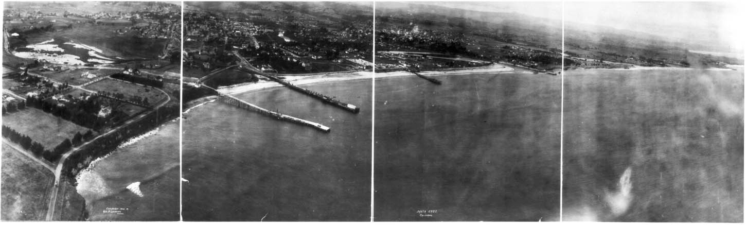
This photograph of Santa Cruz in the summer of 1906 was taken by George Lawrence, an early aerial photographer. Mr. Lawrence began taking pictures from balloons. After falling out of one balloon over 200 feet into the Chicago stockyards, and a second mishap over Minneapolis, he developed a method of keeping his feet on the ground---hauling his cameras aloft with a train of kites.
George Lawrence was partial to big negatives and big cameras. He had one camera that weighed close to a ton (1500 lbs), which produced a negative eight feet long. For aerial photography, he developed a lightweight version, only 900 lbs in weight, which he lifted up with a string of seventeen kites pulling together.
Although George was based in the Midwest, when he heard of the 1906 earthquake he recognized a business opportunity. He brought all his equipment out to California, and took a series of aerial pictures of the ruins of San Francisco. One of those pictures is included in Beaumont Newhall's book, "Airborne Camera", in the Santa Cruz public library. Then he took time to travel around the area, and made more panoramic views of San Jose and Salinas, which you can see in the Map Room at the UCSC library, as well as this picture of Santa Cruz.
The picture of Santa Cruz is dated 1906 on the photograph, but it must have been taken after June 25th. That was the day in 1906 when the old Casino at the Boardwalk burned down. You can see the leveled blank space where the Casino stood in this picture.
Here are some comments on buildings and places in the photo. These locations
are identified with coordinates in inches, measured from the left side
and from the bottom. For example, (8.0, 3.2) is 8.0 inches over from the
left side of the photo, and 3.2 inches up from the bottom edge---where
the Municipal Wharf is today. Most of my information on the two wharves
and a pier which you can see in the picture comes from an article by Ross
Eric Gibson in the July 19, 1994 issue of the Mercury News.
- Epworth-by-the-Sea (2.6, 2.8): big house built 1887, once owned by Bishop Warren, a Methodist Bishop. Small cottage in back is still there.
- 421 Lighthouse Ave. (0.2, 3.1): under construction in this picture, flat top, no roof yet.
- 507 and 511 Lighthouse Ave. (1.0, 3.3): pair of twin houses still there today.
- 523 Lighthouse Ave. (1.5, 3.5): longer corner house, front of house obscured in photo by a tree no longer there. Vacant lot between 511 and 523 Lighthouse Ave. is still a vacant lot today.
- 603 Laguna St. (0.5, 4.0): one story in photo, now raised up with a ground floor beneath.
- Neary's Lagoon (1.5, 4.4): very much a lagoon, in its wild state then. No park, no boardwalks, no sewage plant (presumably they just dumped sewage into the ocean).
- High school terrace (3.0, 5.2): level terrace, where Santa Cruz High is located now.
- High St. (3.0, 5.6): tree line marks gradual ascent of High St., toward the Cowell Ranch to the left.
- Highland Ave. (4.2, 5.5): steep diagonal slash traces Highland Ave., following the route of the present pedestrian path. Modern Highland Ave. zigzags up this hill.
- Judge Logan's house (4.3, 5.6): Judge Logan developed the loganberry (true story). One of the houses at the end of Highland Terrace today has a Loganberry Hgts. sign in the front yard. But the judge's house itself is long gone.
- beginning of San Lorenzo valley (5.0, 5.6): you can see the cleft made by the San Lorenzo river.
- Pasatiempo (6.5, 5.7): broad hill pretty easy to identify, site of golf course today.
- 174 West Cliff Dr. (5.3, 4.0): now owned by the Dream Inn.
- West Cliff RR overpass (5.9, 4.0): was a working bridge in 1906, condemned today and closed to traffic.
- Cowell Wharf (6.5, 3.0): this was the first wharf in Santa Cruz, built by Elihu Anthony in 1849. At the time of this picture it was owned by the Henry Cowell Limeworks, but it collapsed in a storm a year later, in 1907. See how the pier is an extension of Bay St., so they didn't have to haul lumber, cement, and other cargothrough downtown.
- Cowell Beach (6.5, 3.5): exactly where it is today, no surprise here.
- Railroad Wharf (8.0, 3.2): just to the west of the present Municipal Wharf (which was itself built in 1914, seven years after this picture). David Gharkey built the original wharf here in 1856, which became the Railroad Wharf after the South Pacific Coast Railroad bought it in 1875. The railroad tracks ran all the way out to the end of this wharf, which was torn down in 1922.
- Boardwalk casino site (10.0, 4.0): the old casino burned down on June 25, 1906 (there's a picture in the historical exhibit, on the second floor of the present casino, of the preceding building in flames on that day). That helps to date this picture, which must have been taken later that year.
- Pleasure Pier (11, 3.7): this pier at the Boardwalk was built in 1904 with a pipeline carrying sea water to the indoor pool in the plunge building. First called the Electric Pier, because it was lighted at night, it was demolished in 1965, when the plunge was converted to a miniature golf course.
- Pacific Ave. (6.5, 4.6): only the lower end is visible in this picture, but you can see how the buildings line it further up.
- Covered bridge (7.2, 4.9): apparently there was a covered bridge across the San Lorenzo at this point. Old Chinatown was between Pacific Ave. and the river, on the near side of this bridge.
- Holy Cross church (?.?, ?.?): mystery, doesn't seem to appear in the photo. Perhaps it fell into the space between two frames, the separate frames don't match exactly.
- Branciforte Ave. neighborhood (10.0, 5.0): there were only 3 pueblos, or towns, in colonial California, and one of the three was Branciforte, right here. Oldest home still in use in Santa Cruz is adobe building at north end of Branciforte Ave. The residents of Branciforte were mostly ex-convicts, who used Branciforte Ave. as a horse racing track, to the scandal of the missionaries across the river. Perhaps that's why their settlement never quite rivaled San Jose or Los Angeles.
- Loma Prieta (13.3, 5.4): very distinctive outline of this mountain was clear in 1906, it wasn't just flattened at the top for the radio and microwave towers there today.
- San Lorenzo river RR bridge (12.8, 4.1): probably the same bridge as now. Built to higher standards apparently than the West Cliff Dr. overpass.
- Seacliff Beach (15.5, 3.9): a very narrow strip of beach in 1906, and neighborhood inland quite undeveloped.
- Yacht harbor (16.5, 4.0): just a lagoon back then.
- Eaton Ave. bridge (14.6, 4.3): there was a bridge at this location, but not at all as high as the modern bridge.
- Capitola (17.8, 4.4): you can't see the town in the picture,
but it isn't hard to figure where it must be, hidden by the cliff on this
side.
The original negative of this photograph is in the Library of Congress in Washington, D.C. Copies can be ordered from the Photoduplication Dept. at the Library of Congress, at 202/707-5640. You will need to give the Library catalog number for the photograph, which is:
lc-usz62-53410.
| Navigation to the Virtual Santa Cruz Exhibit | |
| 1906 Aerial photo of Santa Cruz | |
| Aerial photos of Santa Cruz | more aerial photos of Santa Cruz |
| Aerial photos of the Central Coast | Index of on-site photographs |
| Map Index of on-site photographs | |
| Navigation to the host Museum of Hiram | |||
| Main Entrance | Astrophotography | Genealogy | Library |
| Chronology | Museum History | Reference | Museum Index |